 |
|
 |
|
|
|
|

|
 |
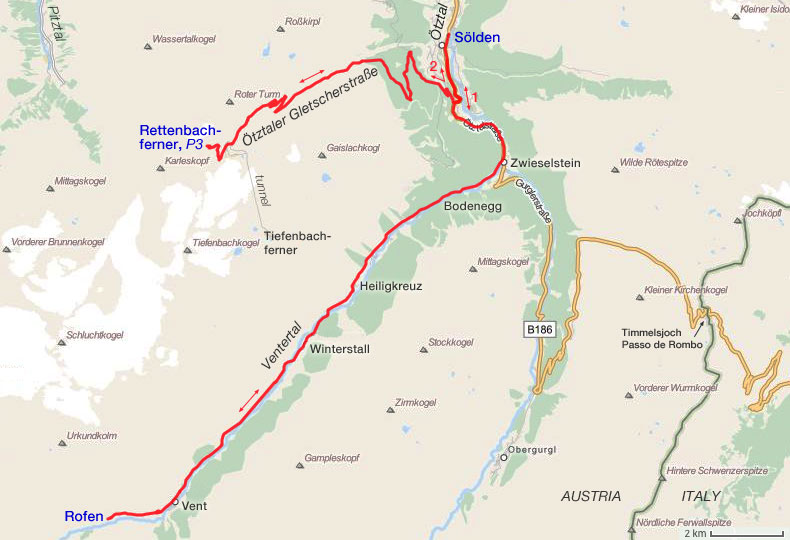
| Left:
ųtztaler Gletscherstrasse. Final destination can be seen in the far
distance. Peak at the center of the photo: Karleskopf (2902 m). Right: Rettenbachferner and parking area no. 1 at 2680 m. Two more photos are shown at the bottom of the page. |
| For many years the ųtztaler
Gletscherstrasse
was on the to do list of climbs that passes the - arbitrary - 2500 meter level. Earlier plans were canceled
because of bad weather. The local weather forecast for 8 and 9
September
was reasonably good. The 8th we started with a training ride to Rofen, the
last hamlet in the Ventertal that can be reached by a paved road. Most
of the afternoon it was raining. Only the four quite long avalanche
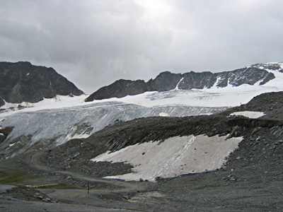
galleries gave a welcome protection. Next day, it was sunny. Time for the ųtztaler Gletscherstrasse, now or never. As the gradient profile below shows, it is a steep climb, but perfectly doable when you have found the right pace. The toll gate, about halfway, is the only nearly flat section. After that it is again steep uphill. At 2630 m you have to decide to continue to the Rettenbachferner, or to turn left to the Tiefenbachferner. The latter can be reached by a 10% ascent through a 1.7 km dead straight tunnel. We have chosen for Rettenbach, although the end point at Tiefenbach is 30 meter higher then the top Rettenbach parking area (P3, 2802 m). At the Rettenbach parking areas there were only a few cars. Clearly off season, although some lifts were still functioning. As the photo's show, the weather can change quickly in the mountains, but the dark rain clouds stayed in the neighboring valley (Pitztal) until late afternoon. The ųtztaler Gletscherstrasse is a good quality, fairly wide road. Without much traffic, descending is a piece of cake and only requires good brakes. |
 |
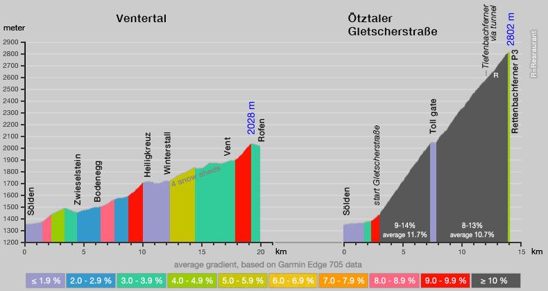 |
| Click here for a gpx.zip file of GPS data of Ventertal track (S÷lden - Rofen; 19.6 km, 432 waypoints). Click here for a gpx.zip file of GPS data of Gletscherstrasse (S÷lden - Rettenbachferner P3; 14.0 km, 925 waypoints). |
 |
 |
| Rettenbachferner seen from parking no. 3 at 2802 m. |
ųtztal seen from the Gletscherstrasse at 2500 m. |
| start page | Ventertal
and ųtztaler Gletscherstrasse |
Passo di
Pampeago and Passo di Oclini |
Redango di
Sopra and Anterivo |
Passo di
Valles and Passo di San Pellegrino |