

Hergensweiler - Kranzegg | Kranzegg - Trauchgau | Trauchgau - Ramsau | Ramsau - Au bei Bad Aibling | Au bei Bad Aibling - Siegsdorf | Siegsdorf - Königssee |
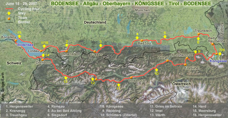
| Day 1. Hergensweiler (520 m) - Oberstaufen - Immenstadt - Kranzegg (855 m). 72 km, 1355 hm (hm = meters uphill). The quiet village of Hergensweiler was chosen as starting point because it offers a better place to safely leave the car behind than the busy and tourist Lindau. The route passes a friendly, hilly environment. Close to Gestratz (24 km from Hergensweiler) the B-K signs indicate another route than indicated on the Esterbauer Radtourenbuch maps. The new, signposted, route avoids the fairly step climb to Grünenbach. Old and new route meet each other at Schönau. Finding your way out of Immenstadt is rather difficult; some sign are confusing or missing. Esterbauer's inset map of Immenstadt helps. Accommodation in Hergensweiler: Hotel Sonne, Dorfstrasse 7; in Kranzegg: B&B (Zimmer mit Frühstück) at Alpweg 3. |


|
Day 2. Kranzegg (855 m) - Haag, near Oy (927 m) - Füssen - Trauchgau (800 m).62 km, 695 hm. The "roof" of the route towards Königssee, with Haag as highest point, offers magnificent views. Shortly after the nice, but overcrowded town of Füssen you will see the famous King Ludwig II fairy-tail castles Hohenschwangau and Neuswanstein. Accommodation in Trauchgau: B&B at Reichenstrasse 21. |


|
Day 3. Trauchau (800 m) - Kochel am See - Bad Heilbrunn / Ramsau
(635 m). |


|
Day 4. Ramsau (635 m) - Bad Tölz - Hausham - Au bei Bad Aibling (512 m).68 km, 740 hm. Ramsau is situated at an alternative B-K route that connects Bad Heilbrunn with Oberfischbach (close to Bad Tölz). The alternative stretch is less easy going (goes frequently up and down), but worthwhile; certainly much more rewarding than following the main road. The old town of Bad Tölz is an nice place for a short break. However, finding your way can be difficult; also here Esterbauer's map helps. The route from Bad Tölz to Gmünd am Tegernsee is choice. The next lake Schliersee - can be admired from a the lovely, quiet road along the west side of the lake. Accommodation in Au bei Bad Aibling: Gästehaus Huber, Hauptstrasse 9. |


|
Day 5. Ai bei Bad Aibling (512 m) - Aschau - Grassau - Siegsdorf (615 m).70 km, 435 hm. For those who are interested in the history of applied sciences it is recommended to visit the Soleleitungsmuseum "Brunnhaus Klaushäusl" shortly before Grassau (along the B-K route). It tells the story of saltwater (Sole) transport from Bad Reichenhall to Rosenheim. The water from sources near Bad Reichenhall contained 24% salt. For salt winning water had to be boiled. Eventually, this practice resulted in a severe shortage of wood for burning fires. Since salt was a very profitable article it was decided to relocate the refinery to a place where wood was still available. For this purpose a ca. 100 km wooden (!) pipeline was build in the early 19th century. The pipeline had to cross several mountain ridges. Therefore a number of pumping-stations were build. The system functioned from 1810 to 1958. Brunnhaus Klaushäusl is the only pumping-station that has not fallen into disrepair. Accommodation in Siegsdorf: Gasthof Edelweiss, Hauptstrasse 21. |


|
Day 6. Siegsdorf (615 m) - Traunstein - Bad Reichenhall - Berchtesgaden
- Königssee (603 m). |
Hergensweiler - Kranzegg | Kranzegg - Trauchgau | Trauchgau - Ramsau | Ramsau - Au bei Bad Aibling | Au bei Bad Aibling - Siegsdorf | Siegsdorf - Königssee |