|
|
|
|
|
|
|
|
 |
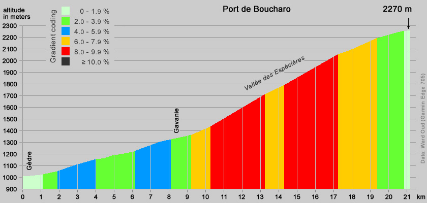
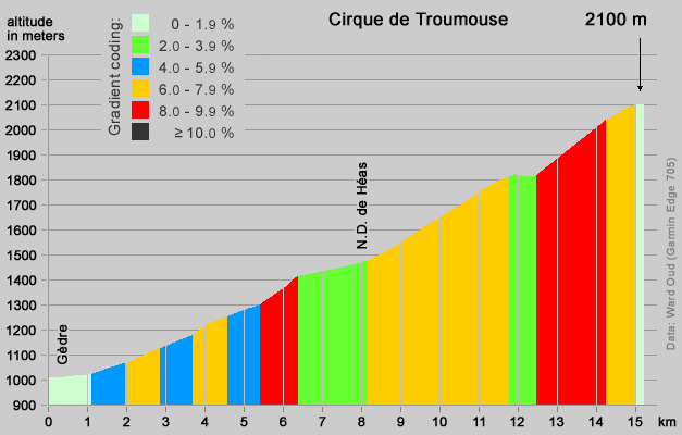
General characteristics (click for gradient profiles or photos). By car: Argelès-Gazost [450m] - 27 km D921 - Gèdre [1020m]. By bike (1): Gèdre [1020m]
- 9 km uphill - Gavarnie [1370m] - 13 km uphill
- Port de Gavarnie (car park) [2210m] - 1.5 km uphill -
French/Spanish border: Port de Boucharo [2270m.] / Puerto de
Bujaruelo [2273m]. By bike (2) : Gèdre [1020m] - 8 km uphill - Notre-Dame de Héas [1521m] - 7 km uphill - Cirque de Troumouse [2138m]. The last 7 kilometers to the Cirque de Troumouse is a toll road, but free to cyclists. |
| When cycling in the Central Pyrenees climbing the Col du Tourmalet is evident, but to my (i.e. Oof's) opinion the Pont de Boucharo is more rewarding. In particular the last 13 km, after Gavarnie is great, in all respects. The Cirque de Troumouse is hardly less appealing. Both ask for a quite a physical effort and offer beautiful views. There is much less traffic on these roads, compared to the classical Pyrenees climbs, which has an advantage when descending. The fact that the road to the Port the Boucharo brings you to the Spanish border and is one of the highest climbs suitable for racing bikes in the Pyrenees can be regarded as a bonus. Both climbs are highly recommended ! One can be done in the morning, the other in the afternoon. |
  |
  
 Bottom left: last kilometer to the Spanish border; middle: last meters; right: Spain, Puerto de Bujaruelo. |
|
|
|
|